MAPS: Request map makers for help

Tips and tricks for the designers, playtests.

Moderator: Wonderdoctor

salexpg2
Private First Class
Private First Class
Posts: 51
Joined: 2020-06-21 13:49, Sunday

Re: MAPS: Request map makers for help

Post by salexpg2 »

Hi again
Next year i want to make a campaign about the 13. Panzer-Division and, you know it, it was positioned in the Mius-Stellung as well. But i don't know the exact campaign path yet as other important maps are missing as well (Dnipropetrovsk).
I forgot to mention that I will be more than happy to contribute to that campaign. I spent a lot of time with Soviet order of battle papers and situation maps, so I can provide my input.

Regards, Alex
User avatar
randowe
Lieutenant Colonel
Lieutenant Colonel
Posts: 2953
Joined: 2019-09-20 19:02, Friday
Location: Germany

Re: MAPS: Request map makers for help

Post by randowe »

Sorry for the long text :bonk :lol

The 13. Panzer Division will start with two scenarios in Poland (Radom and Deblin; maps have to be made yet) and two scenarios in France (Laon, Amiens; maps exist). The 13th was a motorized ID back then.
I downloaded all situation maps i need for Poland 1939, France 1940 and Eastern Front. Only Eastern Front 1944 is hard to find.
All these situation maps will be my main source for the campaign.

Maybe you saw the list of divisional core units the player will get in my Efile thread. But for the opponents i'll not go that deep into detail. So there will be no naming down to battalion or company level like for the core units. I just don't have the time to research all that and i guess most players don't care anyway :bonk Some enemies may just be named on army or corps level.
Anyway, i still need to make a bunch of maps before i can start with the campaign. There also two Caucasus maps missing, next to Radom, Deblin, Dnipro... i am just one man :dunno

In my Efile thread i also mentioned the disproportional core size and map scale. The player has 24 core units, while on many maps a division should not have more than 10 units. But it also depends how dispersed a division was across a certain area.
When i take the Taman Peninsula map 1448 for a Kuban Bridgehead scenario, the 24 core units of the 13th PzD barely fit into the place and i probably have to skip some auxiliary units.

Speaking about Taganrog, for now i will proceed as i have mentioned before. I will create one summer map with Taganrog in the east, for a scenario about the capturing of the city in my Axis Black Sea campaign. The scenario will fit in between Berdyansk/Battle of the Sea of Azov and Rostov I.
For scenarios about the Mius front (Mius-Stellung) i would have to make two additional maps, summer and winter and as i have said, these maps are not on my list yet.
You know there was a German bridgehead around Taganrog in the south of the Mius front. It looks the front runs along the Sambek river from its mouth northwards to the city of Sambek. Then the front runs further northwards along the Kopani stream. Somewhere in the middle between Pokrovskoye and Matveyev-Kurgan the front turns and meets the Mius river.
Image
salexpg2
Private First Class
Private First Class
Posts: 51
Joined: 2020-06-21 13:49, Sunday

Re: MAPS: Request map makers for help

Post by salexpg2 »

Hi Randowe
Speaking about Taganrog, for now i will proceed as i have mentioned before. I will create one summer map with Taganrog in the east, for a scenario about the capturing of the city in my Axis Black Sea campaign. The scenario will fit in between Berdyansk/Battle of the Sea of Azov and Rostov I.
For scenarios about the Mius front (Mius-Stellung) i would have to make two additional maps, summer and winter and as i have said, these maps are not on my list yet.
You know there was a German bridgehead around Taganrog in the south of the Mius front. It looks the front runs along the Sambek river from its mouth northwards to the city of Sambek. Then the front runs further northwards along the Kopani stream. Somewhere in the middle between Pokrovskoye and Matveyev-Kurgan the front turns and meets the Mius river.
Well, this is the point I was trying to make. Mius-Stellung was running from the Sea of Azov along the Sambek river, and it was defended by LSSAH in 1941/1942. And since the Sambek river is very close to Taganrog, I thought that it would be quite a straightforward thing to include that area into the Taganrog map. I assume that you would not put Taganrog right on the map edge, but maybe somewhere half-way between the center and the east edge. And if we create summer and winter Taganrog maps, then they can be used for a number of different campaigns and scenarios.
Mius-Stellung was penetrated only in August 1943, around Kuybyshevo village, but this area is not around Taganrog and for that, indeed, a completely new map will be needed.
...But for the opponents i'll not go that deep into detail. So there will be no naming down to battalion or company level like for the core units. I just don't have the time to research all that and i guess most players don't care anyway :bonk Some enemies may just be named on army or corps level.
Feel free to use me for that purpose. I prefer to name enemy units to the level of battalion because it helps later to revise and fix scenarios. And I do appreciate a lot scenario designers investing time into that.
By the way, I am in the process of finishing Melitopol counter-attack scenario for LSSAH, after which I plan to revise existing Rostov scenarios. Feel free to re-use them later for your campaign because I plan to model accurately German and Soviet OOB.

Regards, Alex
User avatar
randowe
Lieutenant Colonel
Lieutenant Colonel
Posts: 2953
Joined: 2019-09-20 19:02, Friday
Location: Germany

Re: MAPS: Request map makers for help

Post by randowe »

Hey Alex :howdy

Made all the rivers of the Berdyansk map today and made a lot of progress. I even enlarged the map to my favorite size 3150x3000 pixel. Then i thought i could enlarge the Taganrog map as well and then you will have enough space on the right to deploy some attacking Soviets. Or you crop the map to your liking.

Let me ask, do you use the big Melitopol map or do you use a reduced size because you did not upload a smaller map yet?

Here is how Taganrog would look like at 3000x3150 pixel. There is even Kuybyshevo at the northern map edge, but i am not paying attention to that particular village for this map.

Image
Image
salexpg2
Private First Class
Private First Class
Posts: 51
Joined: 2020-06-21 13:49, Sunday

Re: MAPS: Request map makers for help

Post by salexpg2 »

Hi Randowe
Let me ask, do you use the big Melitopol map or do you use a reduced size because you did not upload a smaller map yet?
I am in the process of finishing "Melitopol counterattack" scenario in which I focus on the upper left corner of the map. I have not uploaded a small map yet and I am wondering whether I need to do that all. At least the scenario design tool can handle a case when the background image is larger than the MAP file. So if the game engine can do the same, then we are all good.
As a side topic, speaking about large maps there should a concept of a "viewport" so that map designers can focus on creating large maps, while scenario designers can choose flexibly which area should be shown by the game engine without cropping/reducing maps and uploading them to the database under different IDs. This would be a new idea for Luis :)
Here is how Taganrog would look like at 3000x3150 pixel. There is even Kuybyshevo at the northern map edge, but i am not paying attention to that particular village for this map.
Looks really good! Can you send me a link to the same map in a better resolution so that I can check rivers and villages at the east edge?

Regards, Alex
User avatar
randowe
Lieutenant Colonel
Lieutenant Colonel
Posts: 2953
Joined: 2019-09-20 19:02, Friday
Location: Germany

Re: MAPS: Request map makers for help

Post by randowe »

salexpg2 wrote: 2020-11-18 13:15, Wednesday I am in the process of finishing "Melitopol counterattack" scenario in which I focus on the upper left corner of the map. I have not uploaded a small map yet and I am wondering whether I need to do that all. At least the scenario design tool can handle a case when the background image is larger than the MAP file. So if the game engine can do the same, then we are all good.
As a side topic, speaking about large maps there should a concept of a "viewport" so that map designers can focus on creating large maps, while scenario designers can choose flexibly which area should be shown by the game engine without cropping/reducing maps and uploading them to the database under different IDs. This would be a new idea for Luis :)
Of course you dont have to upload a small map. I just asked because i thought you mentioned earlier that you use smaller maps. Maybe i just remember it wrong :bonk
Btw, which Efile do you use? Was it Adlerkorps?

salexpg2 wrote: 2020-11-18 13:15, Wednesday Looks really good! Can you send me a link to the same map in a better resolution so that I can check rivers and villages at the east edge?
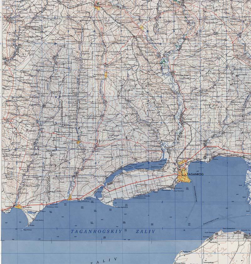
Here is a link to the original maps i use as base for my maps. Taganrog is on sheet NL 37-2

http://legacy.lib.utexas.edu/maps/ams/eastern_europe/
Image
salexpg2
Private First Class
Private First Class
Posts: 51
Joined: 2020-06-21 13:49, Sunday

Re: MAPS: Request map makers for help

Post by salexpg2 »

Hi Randowe
Of course you dont have to upload a small map. I just asked because i thought you mentioned earlier that you use smaller maps. Maybe i just remember it wrong :bonk
Btw, which Efile do you use? Was it Adlerkorps?
Yes, Adlerkorps Efile.
Here is a link to the original maps i use as base for my maps. Taganrog is on sheet NL 37-2
http://legacy.lib.utexas.edu/maps/ams/eastern_europe/
Ok, now I can see better where exactly the Taganrog map edge will be. There should be enough space for attacking Soviet forces if I use it for the "Mius-Stellung" LSSAH scenario.
So, do you plan to produce only the summer map or both summer and winter? As I am interested in having both, I can help with the winter map the way I can (even though I have no idea how you create maps).

Regards, Alex
User avatar
randowe
Lieutenant Colonel
Lieutenant Colonel
Posts: 2953
Joined: 2019-09-20 19:02, Friday
Location: Germany

Re: MAPS: Request map makers for help

Post by randowe »

:howdy
I'm sorry, but as i've said before, i have still a long list of maps to do and i have no time to add yet another map. So there will be a summer only for now.
I dont' know if there is another map maker active at the moment?

Maybe you can use the eastern [EDIT: of course i meant the western part of the map :bonk ] part of map no. 1075? It is not very detailed but maybe there is enough space to set up the german defensive line :huh

kind regards
Clemens
Last edited by randowe on 2020-11-19 11:40, Thursday, edited 1 time in total.
Image
sympatyk
Major
Major
Posts: 641
Joined: 2019-10-03 17:05, Thursday

Re: MAPS: Request map makers for help

Post by sympatyk »

randowe wrote: 2020-11-18 22:05, Wednesday :howdy
I'm sorry, but as i've said before, i have still a long list of maps to do and i have no time to add yet another map. So there will be a summer only for now.
I dont' know if there is another map maker active at the moment?
:howdy
This is actually true
Your maps match the classic ones better - so don't be surprised that people want more and more of them
I admire you finding time for all these projects
... If you were to work with layers - the transition from the picture summer - winter takes only a moment (1-3 hours) ....
User avatar
LuisGuzman
General, Special Forces
Posts: 673
Joined: 2019-03-10 08:35, Sunday
Location: Spain
Contact:

Re: MAPS: Request map makers for help

Post by LuisGuzman »

salexpg2 wrote: 2020-11-18 13:15, Wednesday As a side topic, speaking about large maps there should a concept of a "viewport" so that map designers can focus on creating large maps, while scenario designers can choose flexibly which area should be shown by the game engine without cropping/reducing maps and uploading them to the database under different IDs. This would be a new idea for Luis :)
Interesting idea, but I'd say it would be better to implement in the game, defining a big map and then a top-left and bottom-right positions to use that "viewport" as the battlefield, instead of loading different ID to the map's database.

Something to think in a future :ihope
  Visit my website to get my latest tools.
salexpg2
Private First Class
Private First Class
Posts: 51
Joined: 2020-06-21 13:49, Sunday

Re: MAPS: Request map makers for help

Post by salexpg2 »

Hi

I'm sorry, but as i've said before, i have still a long list of maps to do and i have no time to add yet another map. So there will be a summer only for now.
I dont' know if there is another map maker active at the moment?
This is actually true
Your maps match the classic ones better - so don't be surprised that people want more and more of them
I admire you finding time for all these projects
... If you were to work with layers - the transition from the picture summer - winter takes only a moment (1-3 hours) ....
@randowe: I am not intending to step on your map designer toes, but if transition from the summer to the winter map is indeed a matter of replacing the corresponding "terrain" layer, then can we consider leveraging other map designers to do that change? I have been also working a lot with layers (but not for maps though), so I can try to do that.

Regards, Alex
salexpg2
Private First Class
Private First Class
Posts: 51
Joined: 2020-06-21 13:49, Sunday

Re: MAPS: Request map makers for help

Post by salexpg2 »

Hi Luis
As a side topic, speaking about large maps there should a concept of a "viewport" so that map designers can focus on creating large maps, while scenario designers can choose flexibly which area should be shown by the game engine without cropping/reducing maps and uploading them to the database under different IDs. This would be a new idea for Luis :)
Interesting idea, but I'd say it would be better to implement in the game, defining a big map and then a top-left and bottom-right positions to use that "viewport" as the battlefield, instead of loading different ID to the map's database.

Something to think in a future :ihope
Yes, the intention is to avoid loading different IDs to database. Instead, the scenario file (XSCN) can have new parameters defining a "viewport" for the battlefield.

Regards, Alex
User avatar
randowe
Lieutenant Colonel
Lieutenant Colonel
Posts: 2953
Joined: 2019-09-20 19:02, Friday
Location: Germany

Re: MAPS: Request map makers for help

Post by randowe »

salexpg2 wrote: 2020-11-19 08:34, Thursday Hi

I'm sorry, but as i've said before, i have still a long list of maps to do and i have no time to add yet another map. So there will be a summer only for now.
I dont' know if there is another map maker active at the moment?
This is actually true
Your maps match the classic ones better - so don't be surprised that people want more and more of them
I admire you finding time for all these projects
... If you were to work with layers - the transition from the picture summer - winter takes only a moment (1-3 hours) ....
@randowe: I am not intending to step on your map designer toes, but if transition from the summer to the winter map is indeed a matter of replacing the corresponding "terrain" layer, then can we consider leveraging other map designers to do that change? I have been also working a lot with layers (but not for maps though), so I can try to do that.

Regards, Alex
:howdy Alex

Every classic style winter map has to be made from scratch!
There is no way to turn a summer river into a winter river for example. Sympatyk's map making style is different to the classic style and maybe it is possible to do that with his style, but i can not do the same with the classic style. This has nothing to do with layers or no layers. I can not simply shift the colors of my background layer to white for example.
Somebody tried, you can see it when you check the Stalingrad maps no 41 and no 742. I will not do that because it does not look very good imo.
Sorry, but i am no photoshop wizard :dunno :lol What i know, i learned by myself when i was a child :lol

Of course everybody can take my maps and is free do do whatever he/she wants do do with them. Once they are uploaded at mapfinder, they are property of the community and can be reworked and transitioned into a new map.

[EDIT: There are also Stalingrad maps no 274 and no 782, where the winter map is a mod of the summer map. But again, the winter map looks not as good as the summer map.]

[EDIT2: And i want to say, i made so many maps, i dont understand why i have to defend myself when i say i can not do something :dunno There are millions of more skilled photoshop users out there, but i can not tweak a summer map into a winter map. Last word from me on this topic]
Image
User avatar
LuisGuzman
General, Special Forces
Posts: 673
Joined: 2019-03-10 08:35, Sunday
Location: Spain
Contact:

Re: MAPS: Request map makers for help

Post by LuisGuzman »

randowe wrote: 2020-11-19 11:10, Thursday [EDIT2: And i want to say, i made so many maps, i dont understand why i have to defend myself when i say i can not do something ... ]
:lol :lol :lol your are quite right, you don't need to apologize at all :clap :clap :clap
  Visit my website to get my latest tools.
sympatyk
Major
Major
Posts: 641
Joined: 2019-10-03 17:05, Thursday

Re: MAPS: Request map makers for help

Post by sympatyk »

randowe wrote: 2020-11-19 11:10, Thursday [EDIT2: And i want to say, i made so many maps, i dont understand why i have to defend myself when i say i can not do something ... ]
:howdy

@ randowe
My post was not against you
Sorry if you read it that way

As I wrote - I admire you that you are able to create so many projects at the same time.
Your maps are very pretty

I do not know English -> not always - what I will write - is consistent with what I wanted to write
We used to talk about the drawing technique -> I know you don't have time for that
I'm not trying to persuade you to do -> what you don't want

I will try to present (I don't know if it will be understandable) how summer / winter conversions can be done and why I was talking about layers ..
... and why, there's not much more work .... and why it's more flexible ... and why you can - this way - make classic maps

I think the program doesn't matter here ..
salexpg2
Private First Class
Private First Class
Posts: 51
Joined: 2020-06-21 13:49, Sunday

Re: MAPS: Request map makers for help

Post by salexpg2 »

Hi randowe
[EDIT2: And i want to say, i made so many maps, i dont understand why i have to defend myself when i say i can not do something :dunno There are millions of more skilled photoshop users out there, but i can not tweak a summer map into a winter map. Last word from me on this topic.
I assume that nobody was for forcing you to do something. In fact, we were contemplating ways how we can help you in transforming the summer map into the winter one if you do not have time for that. If you effectively have to create a completely new map to transform the summer map - it is indeed large amount of work. I thought that you have a layer with common elements (such as rivers, cities, villages), and then you just replace the "terrain" layer.

Regards, Alex
sympatyk
Major
Major
Posts: 641
Joined: 2019-10-03 17:05, Thursday

Re: MAPS: Request map makers for help

Post by sympatyk »

:howdy

I tried to change the (classic) summer map to winter - the background image is easy, - worse roads and rivers, and cities are a failure because they need a dark background (they are white) -> I used blue light and contrast -> to make them stand out from the background - -> weak effect
... But if they were on separate layers (roads, rivers, forests, cities, airports) ... then anything can be done with them
All the difficulty and time -> to mark / extract from scratch - roads, rivers, forests, cities, airports ...

https://drive.google.com/file/d/1wEFH_n ... sp=sharing
User avatar
Guille
Captain
Captain
Posts: 33
Joined: 2019-10-20 13:21, Sunday

Re: MAPS: Request map makers for help

Post by Guille »

randowe wrote: 2020-11-19 11:10, Thursday Somebody tried, you can see it when you check the Stalingrad maps no 41 and no 742.
Thanks for the compliment :rollin
One last fight, it's the death throes of the 3rd Reich
Justice shall be done, The final battle remains
Ammo is running low, they're depleting their machine guns
Every bullet counts until surrender is announced

Sabaton - The Last Battle
User avatar
randowe
Lieutenant Colonel
Lieutenant Colonel
Posts: 2953
Joined: 2019-09-20 19:02, Friday
Location: Germany

Re: MAPS: Request map makers for help

Post by randowe »

Guille wrote: 2020-11-19 19:33, Thursday
randowe wrote: 2020-11-19 11:10, Thursday Somebody tried, you can see it when you check the Stalingrad maps no 41 and no 742.
Thanks for the compliment :rollin
Sorry Guille, if i sounded to harsh. Due to my poor english skills i often sound less polite than i want to :bonk
I just wanted to make the point that it is not possible to simply turn a summer map into a winter map. Because it is always visible that it is not a true winter map made from scratch but a converted summer map. I understand that it is an option to do so, because time is also a limiting factor and there can be more reasons as well. But personaly, i am not going to use this procedure, even if people want me to do so.

[Now i am really out of this whole discussion :yes ]
Image
User avatar
lvjtn
General, VII. Upper Danubian Corps
Posts: 768
Joined: 2019-03-09 23:23, Saturday
Location: budapest / hungary
Contact:

Re: MAPS: Request map makers for help

Post by lvjtn »

:howdy Guille! it's nice to see you again!

***

Clemens, you are absolutely right: "winterization" is not an easy task, even for icons or terrain layers for tiled maps, it can be very time consuming. and i think nobody can question your commitment for making excelent maps! :clap :bow
»my real name is csaba (tʃɒbɒ)«
efiles:
Image Image Image Image Image

campaigns:
Image
User avatar
Guille
Captain
Captain
Posts: 33
Joined: 2019-10-20 13:21, Sunday

Re: MAPS: Request map makers for help

Post by Guille »

randowe wrote: 2020-11-19 20:02, Thursday Sorry Guille, if i sounded to harsh. Due to my poor english skills i often sound less polite than i want to :bonk
I just wanted to make the point that it is not possible to simply turn a summer map into a winter map. Because it is always visible that it is not a true winter map made from scratch but a converted summer map. I understand that it is an option to do so, because time is also a limiting factor and there can be more reasons as well. But personaly, i am not going to use this procedure, even if people want me to do so.

[Now i am really out of this whole discussion :yes ]
Don't worry. I didn't take it as a personal attack. It's not one of my best maps by far. In fact, I tried to "winterize" maps as a way to speed its making as I think that mapmaking it's the more time consuming part of designing a scenario, and at the end I spent more time doing it that way. :bonk

Keep up the good work, your maps are very nice and you make a lot of them :bow
One last fight, it's the death throes of the 3rd Reich
Justice shall be done, The final battle remains
Ammo is running low, they're depleting their machine guns
Every bullet counts until surrender is announced

Sabaton - The Last Battle
User avatar
Guille
Captain
Captain
Posts: 33
Joined: 2019-10-20 13:21, Sunday

Re: MAPS: Request map makers for help

Post by Guille »

lvjtn wrote: 2020-11-19 20:04, Thursday :howdy Guille! it's nice to see you again!
Thank you. It's good to be back :howdy
One last fight, it's the death throes of the 3rd Reich
Justice shall be done, The final battle remains
Ammo is running low, they're depleting their machine guns
Every bullet counts until surrender is announced

Sabaton - The Last Battle
salexpg2
Private First Class
Private First Class
Posts: 51
Joined: 2020-06-21 13:49, Sunday

Re: MAPS: Request map makers for help

Post by salexpg2 »

Hi Randowe

For the Taganrog map, you may find useful the following document that summarizes all airfields/bases used by Soviet forces and Luftwaffe. It requires some time to search for airfields you need as all the places are just in the alphabetical order. However, you can use "Taganrog" keyword to fetch the corresponding items.
http://www.ww2.dk/Airfields%20-%20Russi ... kraine.pdf

Let me know if you need help - I can copy/paste the corresponding excerpts from the document.

Regards, Alex
User avatar
randowe
Lieutenant Colonel
Lieutenant Colonel
Posts: 2953
Joined: 2019-09-20 19:02, Friday
Location: Germany

Re: MAPS: Request map makers for help

Post by randowe »

salexpg2 wrote: 2020-11-23 10:36, Monday Hi Randowe

For the Taganrog map, you may find useful the following document that summarizes all airfields/bases used by Soviet forces and Luftwaffe. It requires some time to search for airfields you need as all the places are just in the alphabetical order. However, you can use "Taganrog" keyword to fetch the corresponding items.
http://www.ww2.dk/Airfields%20-%20Russi ... kraine.pdf

Let me know if you need help - I can copy/paste the corresponding excerpts from the document.

Regards, Alex
Thanks :howdy but i already know the documents. I had also added the link to our table (second one) of useful links some time ago: viewtopic.php?p=110#p110
Image
salexpg2
Private First Class
Private First Class
Posts: 51
Joined: 2020-06-21 13:49, Sunday

Re: MAPS: Request map makers for help

Post by salexpg2 »

Hi
randowe wrote: 2020-11-23 12:27, Monday
salexpg2 wrote: 2020-11-23 10:36, Monday Hi Randowe

For the Taganrog map, you may find useful the following document that summarizes all airfields/bases used by Soviet forces and Luftwaffe. It requires some time to search for airfields you need as all the places are just in the alphabetical order. However, you can use "Taganrog" keyword to fetch the corresponding items.
http://www.ww2.dk/Airfields%20-%20Russi ... kraine.pdf

Let me know if you need help - I can copy/paste the corresponding excerpts from the document.

Regards, Alex
Thanks :howdy but i already know the documents. I had also added the link to our table (second one) of useful links some time ago: viewtopic.php?p=110#p110
True, I missed that link :)
By the way, do you have a good source for OKL military records? I am figuring out which Luftwaffe "Geschwader" units were active during the Melitopol counter-attack operation, but I was not able to find a reliable source for that data. Most articles I saw have very vague descriptions.

Regards, Alex
User avatar
randowe
Lieutenant Colonel
Lieutenant Colonel
Posts: 2953
Joined: 2019-09-20 19:02, Friday
Location: Germany

Re: MAPS: Request map makers for help

Post by randowe »

Yep, researching Luftwaffe units is much harder than ground units because they are not shown an the maps.
When i am looking for Luftwaffe units i usualy start with the commanding units at Luftflotte (army) level and Korps. Then check the given Geschwader(s).

For example the II. and III. groups (Gruppe) of Jagdgeschwader 77 were closely following the front and were stationed at the airfields of Jassy, Balti, Kishinev, Ceadîr-Lunga, Zebrykowe/Tsebrykove, Nikolayev, Berislaw, Tschaplinka/Chaplynka, Pologi/Polohy, Mariupol, Taganrog and other airfields in the second half of 1941.
The I. group was in Norway at that time!

If you can read german, you can check "Lexikon der Wehrmacht" which gives also a much or less brief overview about the battles and areas a Gruppe fought in. Or use a translator.
The same site, where we can download the airfield documents, offers also information about the Luftwaffe units and their airfields.

Jagdgeschwader 77:

https://www.ww2.dk/air/jagd/jg77.htm
http://www.lexikon-der-wehrmacht.de/Gli ... JG77-R.htm
Image
salexpg2
Private First Class
Private First Class
Posts: 51
Joined: 2020-06-21 13:49, Sunday

Re: MAPS: Request map makers for help

Post by salexpg2 »

Hi Randowe

Thanks for the links - I can start improving my German :)

Speaking of OKL maps, I came across several (OKL?) maps which looked somewhat similar to what OKH was making. The maps showed where Geschwader bases are, with their numbers, and areas where attacks were made. I however was not able to figure out whether OKL was constantly maintaining these maps or it was just one time exercise. I will post a link here if I find them again ...

Regards, Alex
User avatar
randowe
Lieutenant Colonel
Lieutenant Colonel
Posts: 2953
Joined: 2019-09-20 19:02, Friday
Location: Germany

Re: MAPS: Request map makers for help

Post by randowe »

If you ever need help with german texts, feel free to ask.

I think i will add the link to the "home" of the website that offers the airfield ducuments to the links thread as well :yes

At the weekend i downloaded some more situation maps and now i am sure about another scenario on the Taganrog map. At the end of August 1943 the 13. Panzer-Division as well as some other units was cut off from the german front line and pressed against the sea by the soviet attackers. They were able to slip out of the pocket though.
I already built the scenario in my head lol :bonk :lol
Image
salexpg2
Private First Class
Private First Class
Posts: 51
Joined: 2020-06-21 13:49, Sunday

Re: MAPS: Request map makers for help

Post by salexpg2 »

Hi

Yes, exactly, the summer Taganrog map will be useful for quite many scenarios ;)

Speaking of the 13th Panzer Division, I delved into the details of the existing LSSAH "Rostov attack" scenario (Nov 1941) and have noticed that the existing scenario is not accurate and does not show correctly where German divisions are and from where LSSAH was attacking. While revising 13th Panzer division units, I found the following information about which tanks it had (at least by the beginning of the Barbarossa campaign as follows from the German text): "Zu Beginn des Angriffs auf Russland bestand das Regiment aus 45 Panzer II, 27 Panzer III mit 3,7-cm KwK und 44 Panzer III mit 5-cm KwK, 20 Panzer IV und 13 Panzerbefehlswagen". What puzzles me a bit is how these tanks were grouped in tank battalions of the tank regiment. I can of course model these tanks as three units - Pz II, Pz III, and PZ IV with different unit sizes - but maybe there is a better and a more historically accurate way of doing that. I am pretty sure that you have thought about it so your feedback will be useful. The tank regiment had a fancy organisation as I can see three tank battalions with different number of companies in each of them. Feel free to move this discussion to a different thread as I do not want to mix map design issues with order-of-battle modelling principles.

Regards, Alex
User avatar
randowe
Lieutenant Colonel
Lieutenant Colonel
Posts: 2953
Joined: 2019-09-20 19:02, Friday
Location: Germany

Re: MAPS: Request map makers for help

Post by randowe »

salexpg2 wrote: 2020-12-14 19:08, Monday [...] I can of course model these tanks as three units - Pz II, Pz III, and PZ IV [...]
Actually, that's what i would do and what i will do. I would add a command tank though.
I don't think there is a better way to model a Panzer unit in the game - in a reasonable amount of time.
Of course you can use different base streghths and things like that, but thats also a matter of personal taste and designing/playing style.

Niehorster shows the 4. Panzer-Regiment of the 13. PzD had 2 Abteilungen with 1 medium and 2 light companies each (22.06.41).
http://niehorster.org/011_germany/41_or ... pz-13.html
(Niehorster also shows (at an other site) it had 149 tanks, which also is the overall number in your link.)

On 1.11.41 one light company was ideally composed of 22 tanks: http://www.wwiidaybyday.com/kstn/kstn11711nov41.htm
On 1.11.41 one medium company was ideally composed of 19 tanks http://www.wwiidaybyday.com/kstn/kstn11751nov41.htm

Then you need to research the regimental and company staff units and what they had "in store"in the reserve tank detachments.

But of course we never know if a divison had ideally composed units and of course as longer the war continues the actual strength declines... things like that...
One can write books about it :lol

EDIT: Btw, if you want to mention certain villages in your scenarios texts or so, you can give me the names, so i can make sure to draw them on the Taganrog map.
Image
salexpg2
Private First Class
Private First Class
Posts: 51
Joined: 2020-06-21 13:49, Sunday

Re: MAPS: Request map makers for help

Post by salexpg2 »

Hi
Btw, if you want to mention certain villages in your scenarios texts or so, you can give me the names, so i can make sure to draw them on the Taganrog map.
Sure, can you please share draft map so that I can take a look at it?
[...] I can of course model these tanks as three units - Pz II, Pz III, and PZ IV [...]
Actually, that's what i would do and what i will do. I would add a command tank though.
I don't think there is a better way to model a Panzer unit in the game - in a reasonable amount of time.
Of course you can use different base streghths and things like that, but thats also a matter of personal taste and designing/playing style.
[...]
I have been following a very simple rule of thumb that one unit roughly corresponds to one battalion, which works pretty well for infantry and artillery. One infantry battalion is 3-6 companies, which maps nicely to 6 and 12 unit size; and infantry unit of size 10 corresponds to a classical battalion of 5 companies. Same is for the artillery - the classical structure is 3 batteries each 4 guns (12 guns in total) which more or less matches unit size/strength 10. However, this logic works as long as you have more or less uniform battalions, but things get messier with tanks as most armies have a mixed structure. It seems that we have no option but to decompose one tank battalion into several units, each of which will correspond to N companies.

Regards, Alex
User avatar
randowe
Lieutenant Colonel
Lieutenant Colonel
Posts: 2953
Joined: 2019-09-20 19:02, Friday
Location: Germany

Re: MAPS: Request map makers for help

Post by randowe »

salexpg2 wrote: 2020-12-15 06:47, Tuesday
Btw, if you want to mention certain villages in your scenarios texts or so, you can give me the names, so i can make sure to draw them on the Taganrog map.
Sure, can you please share draft map so that I can take a look at it?
There is not much to see yet. I just asked in advance :howdy
Image
User avatar
Wonderdoctor
Generalstabsveterinär
Posts: 420
Joined: 2019-09-20 19:46, Friday
Location: Amsterdam, Dietsland

Re: MAPS: Request map makers for help

Post by Wonderdoctor »

If anyone would like to draw a snow/forest map of the area around Bütgenbach (Battle of the Bulge), I would be super happy.

This is the png at the rigth scale. I can do the mapnames en terrain if required. Good examples are maps 123, 187 and 243.
Image
Image
sympatyk
Major
Major
Posts: 641
Joined: 2019-10-03 17:05, Thursday

Re: MAPS: Request map makers for help

Post by sympatyk »

:howdy

I understand that you expect a classic map ...
I have no cities, I don't want to fight forests either ...
If no one makes such a map for you, you can use this drawing as a consolation ...

https://drive.google.com/file/d/1WW3q7P ... sp=sharing

It's only 3 hours of work - because I was wondering what area to do ... you can safely discard this drawing
I made all the roads - and the designed ones ... can be changed
If you like this drawing, you have to do everything else yourself ...
User avatar
Wonderdoctor
Generalstabsveterinär
Posts: 420
Joined: 2019-09-20 19:46, Friday
Location: Amsterdam, Dietsland

Re: MAPS: Request map makers for help

Post by Wonderdoctor »

sympatyk wrote: 2020-12-19 21:23, Saturday :howdy

I understand that you expect a classic map ...
I have no cities, I don't want to fight forests either ...
If no one makes such a map for you, you can use this drawing as a consolation ...

https://drive.google.com/file/d/1WW3q7P ... sp=sharing

It's only 3 hours of work - because I was wondering what area to do ... you can safely discard this drawing
I made all the roads - and the designed ones ... can be changed
If you like this drawing, you have to do everything else yourself ...
:bow Thank you!
Image
sympatyk
Major
Major
Posts: 641
Joined: 2019-10-03 17:05, Thursday

Re: MAPS: Request map makers for help

Post by sympatyk »

:howdy

The pleasure is on my side, register the map for you :howdy
Major Heinz
Kadet
Kadet
Posts: 639
Joined: 2019-09-21 16:12, Saturday
Location: Koblenz
Contact:

Re: MAPS: Request map makers for help

Post by Major Heinz »

Is anybody interested to make a Paderborn map of this battle?

https://www.youtube.com/watch?v=zMf55PrCR1E&t=1064s
sympatyk
Major
Major
Posts: 641
Joined: 2019-10-03 17:05, Thursday

Re: MAPS: Request map makers for help

Post by sympatyk »

:howdy

Hallo Major Heinz
Wenn Sie ein Bild für eine Karte möchten, benötige ich die Größe des Bildes in Hex und vor allem den zugewiesenen Bereich
Zunächst sieht es aus wie eine Fläche von 30 bis 35 km x 30 bis 32 Kilometer ...
Sie müssen auch angeben, welche Geländetypen und wo - gezeichnet werden sollen ...
.......................
Hello Major Heinz
If you want a picture for a map - I need the size of the picture in hexes, and most importantly - assigned - area
Initially, it looks like an area of 30 to 35 km x 30 to 32 kilometers ...
You also need to designate what types of terrain and where - to draw ...
Major Heinz
Kadet
Kadet
Posts: 639
Joined: 2019-09-21 16:12, Saturday
Location: Koblenz
Contact:

Re: MAPS: Request map makers for help

Post by Major Heinz »

Hello Sympatyk

I was busy last days. Yes, it looks like the map has a size of 30 x 30 kilometres. So I would suggest one kilometer per hex, to give some space for some units. I have taken a screenshot of the area today.

https://abload.de/image.php?img=paderbornmapdkki2.png

But I don`t understand what youz mean with type of terrains? :huh It lokks like there are a lot of woods and fields in this area.
sympatyk
Major
Major
Posts: 641
Joined: 2019-10-03 17:05, Thursday

Re: MAPS: Request map makers for help

Post by sympatyk »

:howdy

I have no idea - what do you think to do on this map and that's why I ask ...
Should there be any water (river)?
Fields for you -> what terrain? -> Could be clean, rough, bacage

The screenshot from the movie looks like this
https://drive.google.com/file/d/1mjSdNm ... sp=sharing

Should all these places be on the map? -> only these?
I zoomed in to 500m
https://drive.google.com/file/d/1cKehPQ ... sp=sharing

There are many rivers, streams -> impassable in some places
There are three airports -> were they then?
There is also a railway line -> was it then?
Major Heinz
Kadet
Kadet
Posts: 639
Joined: 2019-09-21 16:12, Saturday
Location: Koblenz
Contact:

Re: MAPS: Request map makers for help

Post by Major Heinz »

Okay, I see what you mean. I will try to answer.

Fields: I would say northwest and in the south Clear, other field Rough, because it seems that it is not really flat in this regions. I have marked it in the map.

Image

Towns on the map:
I would say yes, all marked towns and additionally the towns Salzkotten (west), Bad Wünnenberg and Amt Wünnenberg (south), Amt Warburg Land (I think Scherfede is a part of Amt Warburg Land) and Marsberg in the farest south.

Rivers and water: I would say Diemel (flows through Scherfede), the unnamed river west of Paderborn (later it seemns to be a stream) should be on the map, also the lakes in the farest northwest and the Aabachtalsperre.

Airfields: Airfields in the south and southwest didn`t exist. There was a Fliegerhorst that today not exist anymore. Here is a link with the location:
https://geohack.toolforge.org/geohack.p ... anguage=de
It seems to be a little more west to the southern airport.
I have no information about the southeastern airport. Maybe it didn`t exist at that time. But I would prefer a map with two airfields, so I would say let this airfield in the map.

Railway line seems to have existed 1945.
sympatyk
Major
Major
Posts: 641
Joined: 2019-10-03 17:05, Thursday

Re: MAPS: Request map makers for help

Post by sympatyk »

:howdy
I superimposed an image from a movie on a google map ... and I was surprised
Some cities are marked (in the picture from the film) in other places, on different roads ..
Differences in yellow

I drew a blue rivers -> at least 30 km long (they have names)
Violet airports (crossed out - dropped)
Two pictures for comparison -> according to google and according to the movie ..

How to make a map? (what to consider)

https://drive.google.com/file/d/1m4x5p9 ... sp=sharing
https://drive.google.com/file/d/14_b-gU ... sp=sharing
User avatar
randowe
Lieutenant Colonel
Lieutenant Colonel
Posts: 2953
Joined: 2019-09-20 19:02, Friday
Location: Germany

Re: MAPS: Request map makers for help

Post by randowe »

Maybe you guys try out these map series, which is very accurate i think:

http://legacy.lib.utexas.edu/maps/ams/central_europe/

Paderborn sheet:

http://legacy.lib.utexas.edu/maps/ams/c ... orn-q3.jpg
Image
Major Heinz
Kadet
Kadet
Posts: 639
Joined: 2019-09-21 16:12, Saturday
Location: Koblenz
Contact:

Re: MAPS: Request map makers for help

Post by Major Heinz »

When looking at Haaren it seems that some cities in the video are at the wrong place. Maybe it was selfdraw and the wrong locations pictures. So I think google is the better option, as it looks like the old map, Clemens has posted, has the same locations.
sympatyk
Major
Major
Posts: 641
Joined: 2019-10-03 17:05, Thursday

Re: MAPS: Request map makers for help

Post by sympatyk »

Clemens :howdy

Thank you for Link.
Railway lines are clearly drawn
I tried on this map and it is compatible with Google ...
sympatyk
Major
Major
Posts: 641
Joined: 2019-10-03 17:05, Thursday

Re: MAPS: Request map makers for help

Post by sympatyk »

:howdy
I scaled the drawing to the size for the game
The image was 35 km -> I made 40 hexes -> better reproduce the railway, road and river (normally they would be in the same hexes)
In yellow - hexed cities
In blue - rivers
In black - a train
How to draw roads -> Clemens map (attached) or a map from the movie?
Do you accept 40 hex (0.875km / hex) or should I do 35 (1km / hex)?

https://drive.google.com/file/d/1ABfaAZ ... sp=sharing
Major Heinz
Kadet
Kadet
Posts: 639
Joined: 2019-09-21 16:12, Saturday
Location: Koblenz
Contact:

Re: MAPS: Request map makers for help

Post by Major Heinz »

:howdy

40 hex is totally okay for me. :yes

I would say draw the roads like in Clemens map, as the map in the video is probably selfmade and wrong.
sympatyk
Major
Major
Posts: 641
Joined: 2019-10-03 17:05, Thursday

Re: MAPS: Request map makers for help

Post by sympatyk »

:howdy

Ready drawing -> was it supposed to be like that?
Who makes mapx?

https://drive.google.com/file/d/1ygRvTg ... sp=sharing
Major Heinz
Kadet
Kadet
Posts: 639
Joined: 2019-09-21 16:12, Saturday
Location: Koblenz
Contact:

Re: MAPS: Request map makers for help

Post by Major Heinz »

Looks good. :yes

Sorry, I don`t really know what I have to do for a MAPX. :huh
sympatyk
Major
Major
Posts: 641
Joined: 2019-10-03 17:05, Thursday

Re: MAPS: Request map makers for help

Post by sympatyk »

:howdy

Okay - I'll do it myself ..
Post Reply